What We Do
Using Geographic Information Systems (GIS), TGA develops, manages, and distributes complex spatial databases resulting in spatial analysis over time and presentation-quality visualizations/graphics utilized in environmental/natural resource litigation and land use projects.
Our Central Data Repository for all collected and vetted spatial data is utilized by all discipline-specific team members and is critical in increasing strategic cohesiveness and decreasing potential disconnects.

Specializing in the analysis of multifaceted land-use issues and environmental impacts over time;
expertly researching, acquiring and integrating historic and current spatial information.
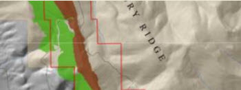
TGA works in conjunction with natural resource and environmental consultants and experts to demonstrate impacts and enhance decision making in the mining, oil/gas, forestry, conservation, and water industries. Our maps and analysis reveal patterns, intensity, and provide context.

We harness the power of GIS for the courtroom or settlements as complex data is effectively visualized and entered into evidence. TGA delivers expert witness reports, depositions, and testimony regarding the spatial and mapping elements of litigation cases.
Our Central Spatial Data Repository for all possible team members on a project is critical to decreasing potential disconnects by holding and vetting all discipline-specific spatial data. TGA establishes and maintains a central authenticated database to manage all of a project’s spatial information.
Copyright 2017 | Temporal Geo Analytics Inc.| All Rights Reserved