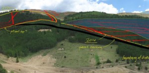
Projects
Superfund – Two On-Going Cases in Pacific Northwest
(One since 2008, the other since 2014)
Working with the US Department of Justice, TGA is compiling, reviewing, analyzing, and reporting on the significance of our efforts in relation to the activities by the United States and other potentially responsible parties (PRPs) before, during and after WWII. We have created and continue to maintain a central forensic spatial database and routinely provide maps, tables, and narrative for the attorneys as well as environmental and historian reports/opinions.
Click Title or Picture below for link to project cut sheet (PDF)
Environmental Litigation – NuWest v. US, Idaho, 2011
CERCLA action to Recover Costs from the US Government
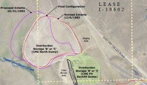
Core to TGA staff’s involvement was mapping post-remediation mine extents (four sites) in relation to US Forest Service and other agency permits and regulations. GPS data and photographs acquired during site visits were utilized as reference in establishing feature boundaries. GPS data collection was also a means to create new line features representing edges of waste areas and pits.
Environmental Litigation – McMillian v. US, Oklahoma, 2010
Determine Share of Oil Refinery Impact Based on Activity Footprint and Term
TGA staff was retained to create and maintain a data repository of all spatial and remotely sensed photographic data relative to an oil refinery located in Oklahoma for the purpose of supporting the US in its evaluation of activities undertaken there before, during and after the Second World War.
Waters of the US – Arizona, US v. Johnson, 2008
Clean Water Act Violation, State of Arizona
Illegal Fill and Destruction of Riparian Environment
TGA staff reviewed and documented the nature and extent of any and all ecological connections in and between river systems in Arizona as related to the investigation of the defendants(s) and the construction related activities resulting in fill to be placed in Waters of the United States without the permit required by the Clean Water Act.

Waters of the US – Michigan, US v. Rapanos, 2007
Clean Water Act Violation, State of Michigan
Violation of Clean Water Act by Depositing Fill in Wetlands Adjacent to Waters of the US
TGA staff worked closely with discipline specific experts to develop and document the presence of a hydrologic connection between three wetland complexes and other established Waters of the US and identified (and displayed) the requisite hydrologic connections present during the time when the impacts occurred.
Anglo Gold Ashanti North America, Cripple Creek and Victor Gold Mine
Visualization (View-Shed and Photo Simulations)
Mining Permit Application, Public Process, Outreach
TGA produced view-shed analyses from 7 significant vantage points to determine what mine activities could be seen in both maximum disturbance and reclaimed terrain conditions. These exhibits were instrumental in demonstrating changes based on engineering data and communicating the nature of the project to local agencies and public concerns.
Land Use Entitlement and Permit Data Management
TGA’s expertise managing project information is not lost on producing accurate and complete entitlement applications in concert with project team members. We work with you to develop strategy for complete applications and manage the process along the way. Let TGA be your central hub for data management and project documentation to make just one phone call for all your answers.
Copyright 2017 | Temporal Geo Analytics Inc.| All Rights Reserved